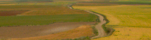
Path to Saugues, Chemin du Puy, France, 2009.
How to use a French Topo-Guide
Part 2 ~ Tips for English language walkers
English-language walkers without much familiarity with French may have an extra challenge when hiking the long-distance trails of France. But it is by no means impossible, and may be both educational and fun. Imagine how impressed your family and friends will be when you return home being able to say “kwarh-SOHn” instead of “crah-sahnt” when you order a croissant. With a little effort, and a small dictionary, it is not too hard to figure out the maps and instructions of the French-language topo-guides (trail guides) published by the FFRP, (the French long-distance trail association).
Of course there is no substitute for learning French (or the language of any country you’re planning to visit), but the concise instructions provided in topo-guides follow a similar pattern, and the list of words you need to interpret them isn’t terribly long. Many of them look very similar to their English equivalents, which makes things even easier. In fact, many English words have been directly added to modern French, much to the displeasure of traditionalists. You can probably figure out the meaning of le weekend. (But do beware of certain faux amis (FOH-ZaMEE), or “false friends”, which are French words that look like English words but have very different meanings).
There are several English-language guides that describe some of the more popular trails, but these are less comprehensive and don’t have the same, excellent IGN (Institute Geographique National) maps that are used in the FFRP guides. It might be helpful to carry one, but it will add weight to your pack, and as I hope you’ll see, is probably not essential. I never have needed one, and I was “very far from fluent” on my first couple of walks. (Nowadays, I’ve progressed to “far from fluent”).
Another great reason to use a French guide is that most French people only speak and read French (imagine that!), so if you get a bit confused, and you meet a French person, you can show him or her your guide and they can help explain. On the other hand, most French people don’t walk on the long-distance trails either, and may not be familiar with those that pass through town, so as soon as they find out you’re trying to get to “that little village”, they may well say, “No, no, no, go this way”, and then start explaining the route you should take – if you were driving! Well, well, we did say this was an adventure…
Here is a little lesson that demonstrates how easy it is to use a topo-guide. It may seem confusing at first glance, but we’ll break it down into the essential facts. The good news is that every other page is basically the same. There are other words as well, of course, but you will see the key words in this exercise again and again. Even on this page, some of the essential words are used several times.
If you haven’t read Part 1 of this article, it may be helpful to do so now. Then follow along as we explore some of the features of FFRandonnée Topo-Guides. If you can, it will be helpful to print out these four documents:
sample map – is a scan of a typical topo-guide map page.
sample text page – is a scan of its corresponding text page.
topo-guide “cheat sheet” – which has definitions of the typical words used in the topo-guides, and on this page in particular.
text breakdown – is an analysis of the words on the sample text page. Study them a bit and see what you can work out.
Now, let’s take a closer look. For those without a printer handy, here is the text.
A Sauvelade, le GR® 65 emprunte la D 110 sur 1 km vers le Sud. Au carrefour, prendre (Sud–Sud-Ouest) le chemin encaissé qui descend dans un vallon et rejoint une crête qu’il suit pour passer devant la maison Chardiesse.
72 – Après une maison béarnaise restaurée (ex-ferme Bignan), l’itinéraire oblique à l’Ouest-Nord-Ouest. A une bifurcation, 600 m plus loin, emprunter la route de gauche sur 300 m.
73 – La quitter pour prendre vers le Sud une piste goudronnée. Passer le ruisseau le Saleys et monter à la ferme Labarthe. Laisser celle-ci à gauche pour s’élever Ouest puis Sud-Ouest jusqu’à la station de pompage. Tourner à gauche (Sud-Sud-Ouest).
74 – A la troisième intersection, bifurquer à droite pour descendre, en sous-bois, vers le ruisseau du Lucq. Le longer pour atteindre Méritien. S’engager à gauche sur la D 947 (croix) pour prendre aussitôt une petite route à gauche. Traverser la D 67 par le souterrain et suivre à droite la D 111 pour entrer dans la cité de Navarrenx.
With the help of the definitions on the “cheat sheet”, you can start by picking out the verbs, which are highlighted in green, below:
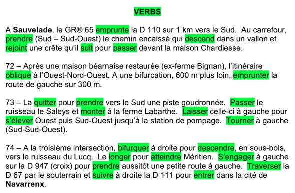
Notice how several of these verbs are used repeatedly, (sometimes in different forms) – prendre, descendre, and suivre are the basic French words for take, descend, and follow. There aren’t too many simple ways to express these actions, so you’ll see them often. Other words look similar enough to their English equivalents that they’re pretty easy to master – passer, monter, and entrer, for example.
It’s worth mentioning that the instructions switch back and forth, sometimes within the same sentence, between what the trail does (it takes the D110), and what you need to do (cross the D67). In practice this doesn’t make much difference. Whether the trail goes up, or you go up, pretty soon you’re going to be higher than you were a little while ago.
Let’s look at some nouns, highlighted in yellow:
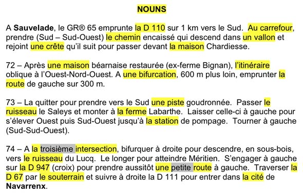
Although there is a much larger list of nouns used to describe a trail, here again, some of them are repeated, like ruisseau, which makes learning them easier. Others are similar to verbs, which is also helpful – a bifurcation is where you bifurquer (a fork is where you branch off one way or the other.
Nouns are always preceded by an article (a, the), and one of the ways you can pick out the nouns is to look for un, une, le, la, l’ and les. (These small words are also used in other ways, not with nouns, but it’s one way to help parse a sentence).
A note about roads. There are three main types of paved roads. “A” roads are large highways, like freeways. “C” roads are smaller, usually 2-lane, regional roads. They’re more likely to have shoulders, and more traffic, than “D” roads, which are are often the “back roads” – frequently narrower, and often quieter. There are other, unclassified roads as well, which may or may not be marked.
Now, on to adjectives:
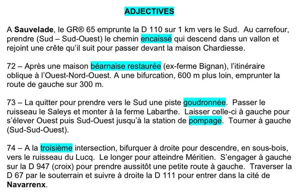
I probably use my dictionary more often for adjectives than any other kind of word. Just like in English, there are plenty of them. Even so, there are many, like goudronnée, which are used over and over again. Others, like encaissé and béarnaise may describe something more accurately, but they’re not the difference between being lost and found.
Finally, the important words about direction:
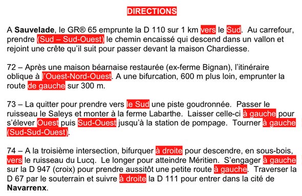
These are key words for the walkabout pathfinder, but there aren’t very many of them, and they’re always the same. You’ve just learned most of them. North is always North, and Left is always Left. The rest are just as easy.
Putting it all together, I get something like this:
At Sauvelade, the GR® 65 takes the D110 for 1 kilometer south. At a crossing, take (south-southwest) the steep-sided path that descends into a valley and then reaches (merges?) a ridge (crest of a hill?) that it follows past the front of the Chardiesse (someone’s name) house.
72 – After a restored Béarnaise-style (we are in Béarn, afterall) house (formerly the Bignan (somebody’s name) farm, the route veers to the west-northwest. At a junction, 600 meters further on, take the left hand fork for 300 meters.
73 – Leave it to take an asphalt track the south. Pass by the stream and climb to the LaBarthe (somebody’s name) farm. Leave it to the left and ascend west, then southwest, to a pumping station. Turn left (south-southwest).
74 – At the third intersection, turn right to go down into the woods toward a stream. Walk along it to reach Méritien. Take the D947 to the left (there is Christian cross there) and immediately take a small road to the left. Cross the D67 by the underpass and follow the D111 to the right to enter the city of Navarrenx.
This is by no means a perfect translation, and there are a couple words that I’m not sure of how they’re being used here. But that’s okay. I’m not using this at home in my easy chair, I’m using it in the field, where I’m able to compare what I think (guess?) it means with what I see around me. I keep track of where I am on the map as I reach locations I’m sure of (like a crossroad), and I can see from my little compass, which way southwest is. And of course, there are many white over red (keep walking ahead) trail marks, indicating the route.
I expect to reach Navarrenx in time for an early dinner. I hope to see you on the trail… – sm